

GPSTest
by barbeauDev · Apache-2.0 · open source
See which GPS, Galileo, GLONASS, BeiDou, QZSS, NavIC and SBAS signals your phone receives, how strong they are and whether Android uses them for a fix.
Needs:Android 7.0+ · location permission · GNSS hardware
2113 Apps is independent, not affiliated with or endorsed by barbeauDev. Official sources: source code on GitHub.
- Version
- 3.10.6
- Size
- 3.5 MB
- Requires
- Android 7.0+
- Updated
- 2026-08-31
Screenshots
Introduction
GPSTest is an open-source diagnostic app originally created by Mike Lockwood and now maintained by Sean Barbeau. It exposes the GNSS information Android makes available. It does not turn the phone into a navigation app or improve the antenna; it helps show whether the phone has a fix, which satellite systems and signals it sees, and whether the hardware exposes carrier-frequency or dual-frequency measurements.
This is the osmdroid edition of GPSTest. Its ordinary Map screen uses OpenStreetMap rather than Google Maps, while Accuracy mode uses MapTiler’s hybrid satellite layer with OpenStreetMap attribution. We matched the hosted file byte for byte to the official osmdroidRelease-v3.10.6.apk from the project’s GitHub release.
What the screens show
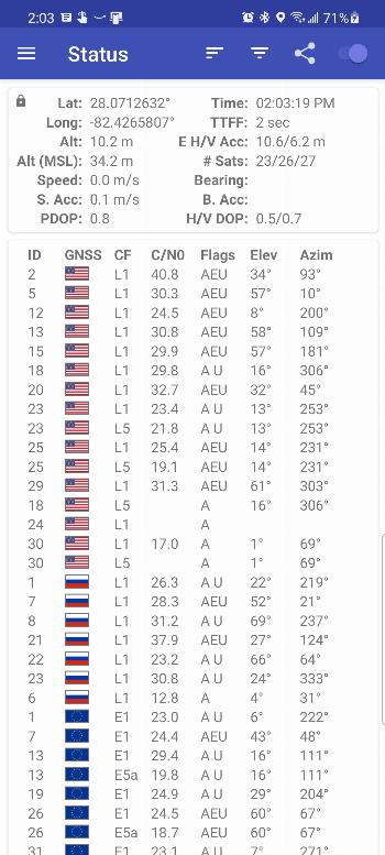
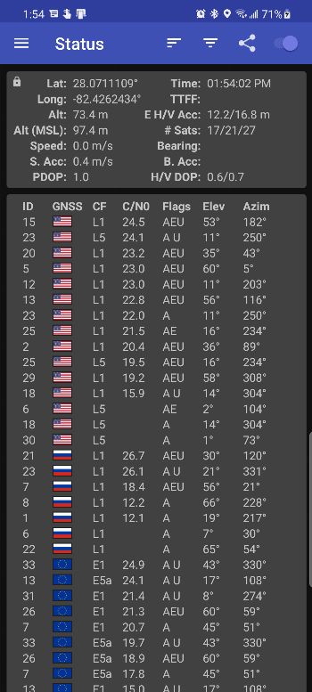
- Status lists satellites and signals, with constellation, satellite ID, carrier frequency, signal-to-noise value, elevation, azimuth and flags showing whether Android has ephemeris/almanac data and uses the signal in the current fix.
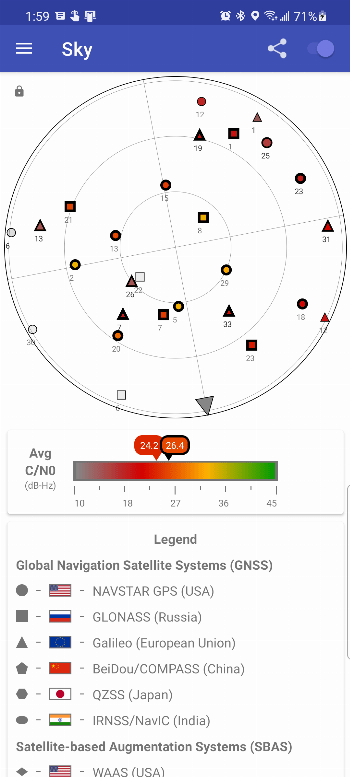
- Sky places satellites around a compass plot. It is useful for seeing whether signals are clustered or blocked in one direction, though the plot alone cannot identify the physical obstruction.
- Map puts the reported fix on OpenStreetMap. Map tiles require network access unless they are already cached; this is not an offline map package.
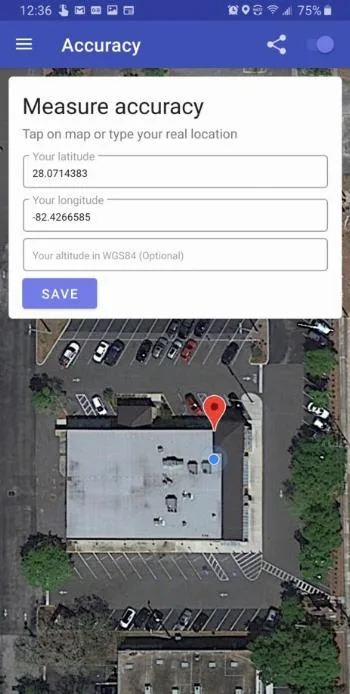
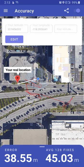
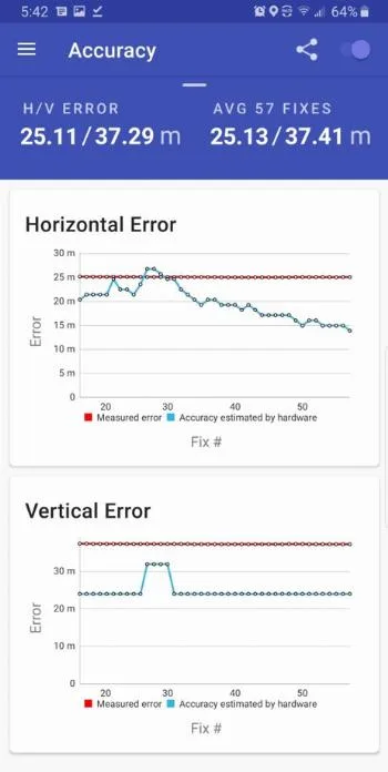
- Accuracy compares fixes with a reference latitude and longitude that you enter, on a MapTiler hybrid satellite map. Its chart plots measured error and Android’s estimated accuracy over time. The comparison is meaningful only when the reference coordinate itself is trustworthy.
Support for GPS, Galileo, GLONASS, BeiDou, QZSS, NavIC and regional SBAS signals still depends on the device. There is no signal-strength-over-time chart in this version.
Terms such as “used in fix” describe what Android reports to the app, not an independent measurement by GPSTest. Indoor reception, the phone case, antenna design, weather, obstructions and manufacturer firmware can all affect what appears.
Logging and troubleshooting
GPSTest can record GNSS and sensor information to CSV while a foreground notification keeps the logging session alive. On current Android versions, exported logs are copied to a user-accessible downloads location. Logs can contain precise location and movement data; review them before sharing.
The menu also exposes Android extra commands for injecting time or PSDS/XTRA assistance and clearing assistance data. These are requests to the operating system. A phone may not implement them, and clearing data can delay the next acquisition. They are most useful when reproducing a receiver problem, not as a guaranteed “GPS booster”.
Version 3.10.6 updates Android platform and core dependencies, fixes the SouthPAN legend colour in dark mode and includes translation work. Its release notes do not claim a universal accuracy improvement.
Privacy and permissions
Location permission is necessary because the app reads GNSS measurements and fixes. The APK declares nine permissions, including those used for location and foreground logging. It has no native libraries and our scan found no tracker SDKs. It still uses the internet for OpenStreetMap and MapTiler tiles, help or requested assistance data. A user-triggered Share → Device action uploads device information to script.google.com; no tracker detection is therefore not the same as no network traffic.
About this file
- This is the developer’s official 3.10.6 osmdroid release APK, signed with original author Mike Lockwood’s key and now maintained by Sean Barbeau. IzzyOnDroid mirrors it unchanged; its SHA-256 and byte size match the GitHub asset.
- It needs Android 7.0 or later. Some measurements, including carrier frequency, require newer Android versions and supporting hardware.
- The 3.5 MB APK contains no native code and declares nine permissions. Our scan found no trackers.
- GPSTest is licensed under Apache-2.0. OpenStreetMap and MapTiler tiles and data have their own attribution and usage terms.
What’s inside the APK
Trackers
No code matching the Exodus Privacy tracker signatures.
Native code
Pure Java/Kotlin, so it runs on any CPU.
Android versions
Built for Android 16 (target API 36).
Permissions
3 of them need your approval first.
Asks you first (3)
Android shows a prompt before the app can use these.
- Approximate location · ACCESS_COARSE_LOCATION
- Precise location · ACCESS_FINE_LOCATION
- Show notifications (Android 13+) · POST_NOTIFICATIONS
Granted at install (5)
Low-risk permissions Android grants automatically, plus any we have not classified.
- ACCESS_LOCATION_EXTRA_COMMANDS
- ACCESS_NETWORK_STATE
- FOREGROUND_SERVICE
- FOREGROUND_SERVICE_LOCATION
- INTERNET
Defined by other apps (1)
Permissions that belong to another app or to this app itself.
- com.android.gpstest.osmdroid.DYNAMIC_RECEIVER_NOT_EXPORTED_PERMISSION
More Information
- Package name
- com.android.gpstest.osmdroid
- Version
- 3.10.6 (build 24100)
- File size
- 3.5 MB (3,457,918 bytes)
- Requires
- Android 7.0 or later
- Category
- Reading & Maps
- License
- Apache-2.0
- Developer
- barbeauDev
- Source code
- github.com/barbeau/gpstest
- Released
- Aug 31, 2026
- Signer SHA-256
- 67e04383a96a83476426adcbdd95c4c75d78028a5c4ada75c00334b1c7a5d706
- File SHA-256
- 897b91fe6a1ea0c3a7f6e2b041d5ace0d582941f67cf454fb7778f031d89ce41
- Checked
- , against the IzzyOnDroid index · how we check · verify it yourself
Common questions
Is this APK the official GPSTest release?
Yes. It is the developer’s own release of GPSTest 3.10.6, byte for byte as IzzyOnDroid distributes it. Its SHA-256 matches IzzyOnDroid’s signed index, and it is signed with the certificate IzzyOnDroid records for the app (SHA-256 67e04383a96a83476426adcbdd95c4c75d78028a5c4ada75c00334b1c7a5d706).
What Android version does GPSTest need?
Android 7.0 or later (API level 24). Version 3.10.6 is built for Android 16 (target API 36). Pure Java/Kotlin, so it runs on any CPU.
Can GPSTest access the internet?
Yes. The APK requests Android’s internet permission. In total it declares 9 permissions, and 3 of them need your approval first.
Does GPSTest contain trackers?
No known trackers: our scan of version 3.10.6 found no code matching the Exodus Privacy tracker signatures. The scan covers known tracker libraries; it doesn’t show what data the app itself sends.
Is GPSTest open source?
Yes. GPSTest is released under the Apache-2.0 licence, and its source code is published at https://github.com/barbeau/gpstest.
Can GPSTest add dual-frequency GPS to my phone?
No. It can display L1, L5 and other frequencies only when the phone’s GNSS chipset, antenna, firmware and Android version expose them. Dual-frequency measurements generally need compatible hardware and Android 8.0 or later. The app diagnoses capability; it cannot create it.
What do inject and clear assistance data do?
They ask Android’s location service to inject time or predicted satellite data, or clear stored assistance data. Manufacturers may ignore those commands. Clearing can make the next fix slower, so it is a troubleshooting step, not a routine way to improve accuracy.
Recent releases
| Version | Released | Size | Requires |
|---|---|---|---|
| v3.10.6 · this download | Aug 31, 2026 | 3.5 MB | Android 7.0+ |
| v3.10.5 | Mar 17, 2025 | 4.3 MB | Android 7.0+ |
Versions currently kept in the IzzyOnDroid repository. We host and check only the newest one. Full changelog.
Alternatives and related apps
-
 Organic Maps Offline maps and navigation for everyday travel rather than diagnosing the GNSS receiver.Download
-
 OsmAnd~ Detailed offline maps, tracks and navigation after downloading a region.Download